Monday, September 3, 2012

THE FRANCONIA RIDGE 9/1/12


The Franconia Ridge 9/1/12


Walking across the ridge


"All paths lead to nowhere. Therefore, pick a path with heart."..
Carlos Castaneda
And with Carlos's quote in mind we head out to climb The Franconia Ridge.  This will be my forth hike of the ridge.  Almost to the day 2 years prior, under the watchful eye of Hurricane Earl, my friends Meena and Dan got married on the summit of Lafayette.  About 19 of us hiked up to witness the nuptials.  Hurricane Earl kept a close eye on the wedding party, darkening and clouding the skies, but sparing us his wrath.
9/4/10: Dan & Meena get hitched on Lafayette while Earl looks on
The other 2 times I've trekked across the Ridge, it has been socked in, no views.  So today, the day of my most recent attempt I was thrilled to hear a pristine weather forecast.  Bluebird skies and cooler, crisp temperatures.  Karen and I pull into the Lafayette Place lot @ 8:00, gear up and are on the trail by 8:15.

We decide to head up the beautiful Falling Waters Trail, walk across the Fanconia Ridge Trail and descend via the Old Bridal Path.  Falling waters. This will bring us over 3 peaks, 2 of which (Lafayette & Lincoln) are over 5,000 feet in elevation, while the 3rd Little Haystack, is well over 4,000 feet, standing at 4,840 ft., but due to a weird Appalachian Mountain Club (AMC) rule it doesn't count on the club's 4,000  footer list due to it standing less than 200 ft. above the col on the ridge above Lincoln.  Yada, Yada, Yada!!!  After the hike I relay this information to Karen and she says, "who cares, it counts as a 4,000 footer to me."  Touché' !!!

Speaking of Karen, her hiking prowess gets stronger and stronger with each trip.  She handled the steep Falling Waters trail like a pro.  We were actually passing many folks as the trek progressed!!!  Ok, I know it isn't a race, but sometimes it's a nice ego boost to kick a little ass!!!! You are humbled though when a member of the Greenleaf Hut Croo comes charging by with a 100 lb. freight-car container strapped to his/her back and excuses his or herself as they blow by you!!! 

Anyway, This hike is truly a New Hampshire classic.  Beautiful water-falls, steep/rocky/challenging terrane, a stunning ridge climb that rivals anything in the state and the opportunity to stop at the Greenleaf hut for a rest-bit and fill your water bottles with the coldest, crispest tasting water on earth, chug ice cold lemonade, while sampling the most decadent vegan brownies you've ever tasted or the greatest high-mountain homemade pizza I've ever eaten (I couldn't resist).  Thank you Greenleaf Croo!!!

The day itself lived up to the forecast, blue skies and temps in the high 50's to low 70's by the time we returned to the car.  I didn't take a ton of pictures, as I was enjoying the trek with my heart.  Below are some of the images I came back with.  If you've never done this hike and are ok with long, exposed trails, some of which are on the steeper side, I recommend this trip.  The Greenleaf hut is 2.9 miles from the parking area and if you go up The Old Bridal path, the route is less challenging then heading up Falling Waters, so it can be done as an overnighter, giving your budding-hiker kids an amazing experience.  You have to work to visit some of the world's finer places and in my eyes, The Lafayette Ridge qualifies as one of them.

A View of Cannon Mountain from the Ridge

Karen & I at the peak of Layfayette 4K #'s 6 & 7 for Karen

Karen enjoying where she is

I'm the King of the world!!!!

Swiftwaters Falls on the Falling Waters Trail

Otherworldly

Monday, August 6, 2012

                                        KATAHDIN

Flexing our muscles on The Knifes Edge
The Mountain was angry my friends, fierce gusty wind gales turned into thunder and then to rain... ok, this was not so, the weather was actually perfect, but I liked my pre-written bad weather intro so much, I needed to use it.

And with that said...  After 6 months of planning and much anticipation, we have arrived at the gate of Baxter State Park to begin our Katahdin adventure. At the ranger Station, I pick up a copy of "Wildnotes", the visitors guide to Baxter State Park.  I am immediately stuck by the fact that it had no advertising, not a one! It gives visitors helpful hints on things like what to do in the event there's no outhouse around ("poop, it isn't fun to talk about, but better to talk about it than to step in it") , how to avoid and manage bear encounters, ect, ect.  Those are helpful tidbits in the wilds of Baxter State Park, but as I read further I become intrigued by the discussion about Governor Percival Proctor Baxter, whose name has become synonymous with both the Park and the highest knob on Katahdin, known as Baxter Peak.

Wildnotes mentions that Gov. Baxter, who as governor donated a  large parcel of land (Baxter State Park) to the people of Maine intended to keep that land "forever wild":
Gov. Baxter

"I seek to provide against commercial exploitation... hotels, advertising, hot-dog stands.. and the trappings of unpleasant civilization"
"Everything in connection with the park must be left simple and natural"
"I want it used but in the right unspoiled way"

And my favorite:
"Man is born to die. His works are short-lived. Buildings crumble, monuments decay, and wealth vanishes, but Katahdin in all it's glory forever shall remain the mountain of the people of Maine."

Gov. Baxter was also an opponent of the Klu Klux Klan, who supported his political opponent and eventual successor to the governorship.  I mention this because it too says something about the character of the man.

From the Visitors gate, we travel 16 miles (driving between 5-20 mph) on unpaved and rugged roads to our campsite. My camping/hiking companions Dan & Meena were forced drive up in their Mini, due to air conditioning issues with their more rugged Subaru.  The Mini showed the effects of the park drive, as upon our arrival to the campsite, it's muffler was hanging low, looking sort of like a tired hikers sagging tongue.  The camp has no running water, a clean outhouse and a ranger station, where you can buy firewood (outside wood is strictly forbidden from entering the park)and nothing else.  No tee-shirts or bumper stickers to be purchased, no snack shack, ect... if you don't bring it, you don't have it! Thank you Gov. Baxter!!!
Our humble Roaring Brook living-quarters

After making camp, we have a great meal, pasta for everybody but me.  I break out my pre-made Whole Foods vegan grub.  Oh, on the way up, we stopped at Whole Foods (my friend Cliff would be proud!) in Portland, where I quickly became a kid in a candy store, since NH is Whole Foods deprived!!! Fellow hiker & passenger Peter (he of pizza and hot-dog purchase at the summit of Mt Washington 2 weeks prior) joins me in Whole Foods and I think I may have made a glimmer of headway in bringing him around to healthier eating, as he purchased ( and enjoyed) some awesome vegan foods.

Prior and after dinner, we hydrate, drinking crazy amounts of water per person.  As you can imagine, the early morning conversation revolved around the world record amount of times we each left our tents during the night for "bio-breaks".

4:00 am, I see a shadowy figure standing outside my tent, shaking keys in a ghost-like fashion and in a Steven King character-like voice I hear a the command "Neil, Neil.. it's time to get up Neil, time to get up".
Oatmeal & tea awaits!!!  At 6:00 am we sign the hikers log and off we go, our anxiously awaited attempt to climb Mt Katadhin begins.

The Helon Taylor Trail:    The trek begins on the Helon Taylor Trail, a trail named after H.N. Taylor, long time superintendent of Baxter State Park.  This trail gives you very little warm-up, you are subjected to an immediate sharp grade up, taking you through very cool forest and scrub.  Large boulders litter the trail, but I wouldn't consider the initial footing rugged.  Views of Katahdin are not very prevalent on the drive up or driving through the park to the Roaring Brook camp grounds, but as we continue to assent the Helon Taylor, we get our first good views of the amazing Mt. Katahdin.
Our first good view f Katahdin from Helon-Taylor
This view, while impressive and awe-inspiring is nothing compared to what was yet to come.  As we ascend the fairly steep Helon Taylor trail, we begin to exceed tree-line.  We are now traveling through huge boulder fields and rock scrabble.  The footing is rough but not treacherous. 
The gang heads up Helon Taylor through the boulder fields
Views of the mountain are now everywhere.  And then, wow moment #1, we pop out into a clearing and the first of what will become an endless environment of astonishing scenery appears in front of us.
Dan, a.k.a Ansel Adams records the first of many spectacular views
We are now above tree-line and heading toward a very steep rock-footed incline that will bring us to the summit of Pamola Peak.  At first glance this incline makes us pause, look at each other and in one way or another, we each say "whoa, holy shit!!!"  Gulp!!!

At this point, adrenaline takes over me and I head up the rocks to Pamola Peak, in what for me was world-record pace. What awaits me on the Peak may be one of the great views on any mountain anywhere..  I've seen pictures of it, I've watched video of it but your first sighting of The Knife's Edge is literally life and mind altering!!!!  As I await arrival of my hiking partners, others appear and their reactions are study in the of expressions of awe.. dropping jaws, wide open eyes, hugs and the ever present "Holy Shit!!!"I watch closely and smile as my folks arrive and I observe their own personal "Holy Shits"!!!    We rejoice on the peak, "Bizzaro Ralph" (Bizarro is the trail name I've given him) attends to some budding blisters and we sit and eat accompanied by a view that is second to none (so we think!).  

Now the real work is about to Start.

Chimney Peak:  

Descending the backside of Pamola is a very steep challenging decline requiring great concentration and maneuvering.  A footing or balance mistake could result in very unwanted consequences.  Once down Pamola, you now are required to climb a short but intimidating peak that shoots straight up right in front of you.  This is known as Chimney Peak.  I was looking for words to describe the Chimney, but couldn't come up with a better  one paragraph description than the one I found on a Summit Post writing, so I'll thank the author and use his/her words:  "Chimney Peak is the small sharp peak adjacent to Pamola, separated by a narrow gap or "chimney". The chimney provides the most technically challenging section of a hike along the Knife Edge, but in good weather requires no special skill beyond an ability not to think about falling."
The approach to Pamola Peak
I arrive @ The summit of Pamola Peak and I'm treated to my first sighting of The Knifes Edge
I am alone with my thoughts as I head across the Knifes Edge (photo by Dan Szczney)

The Knifes Edge:  After successfully climbing the Chimney (to high-fives from strangers who got there before me), it is now time to cross the rest of the Knifes Edge.  I've been thinking about this and training for this so long it is very surreal that I am actually standing on it's surface.  Meena mentions something about my state-of-mind being very zen-like.  I felt zen-like.

The Knifes edge is a 1.2 mile boulder scramble with areas so narrow you have room for your shoe and not much more.  To each side of you is jagged "Lord of The Rings" looking rock spires that would not be hospitable to a falling hiker.  At times you have to sit on jagged edged rocks to maneuver or set up your next move.  I commented to Pete that it's a weird feeling to have a jagged rock pull your butt open and having wind rushing in from both sides!  There are ups and downs as you head toward the ultimate destination, the summit of Katahdin at Baxter Peak.   I've encountered ups and downs on other mountains, we've referred to them as "PUD's", pointless up's and downs.  There is nothing pointless about these ups and downs, they are part of a system of rock larger than us and I quickly realize it is not my place to ask why!  Your mind is all-in as you cross this ridge, it has to be, you become a part of the environment.  One misplaced step or a wrong maneuver can lead to serious physical and/or mental problems.
Left to right: Palmola Peak, Chimney Peak & The Knifes Edge from South Peak
I ascend to the summit of South Peak, there is nobody else up there, so I take this opportunity to jump into a hole between 2 rocks and as I watch the world around me I get rid of some of the water I've been drinking.  To this point the water release has been only in the form of sweat!  Time for lunch, energy for the final push to the summit of Katahdin.  

The summit is close.  From South Peak it looks like most of the ascents hardest work is done.  The next stretch is scrabbly in footing but the elevation gain is moderate.  I am in great spirits and feel strong as I make my way up to the top of the great state of Maine.  I arrive to hoots and hollers of congratulations from strangers already sitting on the summit.  I'm there!!!  Mission Accomplished but unlike the famous guy who said that before me, I realize the rest of the story ( the descent) will be very challenging as well.
This is what awaits you on either side of the Knifes Edge if you make a mistake
Pete & I head up the Knifes Edge (Photo Dan Szczney)


Ridge Walking Katahdin Style!


Standing on top of the State of Maine 
Everybody on the summit is taking photos of everyone else. A couple of girls ask me to shoot a picture of them at the summit sign.  Before I do one asks me how her hair looks.  I inform her "it looks fabulous, like you just climbed Mt. Katadhin".  Laughs.  I congratulate a group of Thru-hikers who are joyfully drinking energy drinks and sitting on the the last of a long list of summits they've walked from Georgia to Maine. One by one my partners arrives... smiles, hand slaps and hugs all around, pure bliss.  A tired and Euphoric Dan hugs the summit sign.  After a half hour or so of rest, pics and celebratory conversation, it's time to begin the 5.5 mile trek "home".  We decide the best way for us to descend is via the saddle trail, the "easier " way down.

Saddle Trail:  The backside of Baxter Peak reminded me of the approach to Mt Washington.  The first mile heading to Saddle is a huge otherworldly rock-pile not particularly steep but tricky and exhausting footing for tired and achy feet.   As you head toward Saddle an impressive view leads your way.  Looking down into the bowl, you are treated to a view of the huge, aggressively-steep rock-slide known as Cathedral.  I now see why tired legs would be wise to avoid coming down this behemoth.  However, my next Katadhin trip goal is to ascend via Cathedral, do the Knifes Edge the opposite way and descend down Pamola.  
Heading Down the backside of Katahdin, Cathedral is the white gash to the left
The top section of the Saddle is an approximate 1.5 mile rock slide that rivals the likes of the Owls Head slide (so much for easy). I pass a tired group of hikers laboring down the slide.  The rest of my group is taking it slow and deliberate, but I feel the need to try to get down as fast as I can, so I wave my hiking sticks in their direction, they respond and off I go, doing the rest of the hike solo and rest-break free.  I push myself hard down the slide, traveling at a personally aggressive pace.  I'm pressing myself to the edge of my personal physical ability, while keeping focused on not idiotically injuring myself.  After descending the slide and and traveling back under tree line, the trail becomes a semi-tedious, a never ending rock-lined pain in the ass.  To break up the monotony, I decide to run, rock hop and pole vault when I can.
Oh good!!!! Chimney Pond, only 2 miles to go.  Those 2 miles become the longest 2 miles of my life.  The terrain is flat but rocky and my mental state is now saying "get me too my tent!!!"..  A trail sign, .1 mile to the Roaring Brook camp ground, yeah!!!  Another sign .2 miles to Roaring brook camp ground..  WTF!!!!  Finally, the ranger station!!! My tent!! My Cooler!!!  A Beer!!!!  
Sometime later, the rest of the gang arrives, they have some food and we all sleep well (no Bio breaks tonight!)

The next morning Ralph heads home early, but the rest of us begin our long ride home by gathering at the Appalachian Trail (AT) Cafe in Millinocket for breakfast and cell phone service!!  The AT Cafe is a popular spot for hikers and trekkers. Katadhin is last call for Thru-hikers completing the AT from Georgia and somebody needs to gather them up. There are woman in the cafe wearing t-shirts that say " My son is an AT hiker".  They are obviously there to greet their returning sons after a 2,160 mile walk in the park. We chat with some other AT Hikers and a bunch of hikers we ran into on the trail.. smiles and good vibes all around..  deprived of cell phone service for over 2 days, Dan, Pete and I realize we are addicted to social media and finally have an opportunity to check our phones while "Mother" Meena scolds us.  I sneak a few photos on to Facebook before Meena notices...  Back to reality! For those of you heading to Katadhin, the coffee served in the upstairs of the AT Cafe is worth the stop in it's self.  A return trip to Whole Foods and back to Gilford...  The trip is done, but the memories are just evolving and maturing.

From the summit of Katadhin, one can look in all directions, seemingly hundreds of miles all ways and see absolutely nothing man-made.. nothing.  Not a building, phone tower, hotel, hostel, lodge, restaurant, hot dog stand, shopping mall, Applebees, Walmart or McDonald's... nothing not a thing..   Awesome, awesome, fucking awesome!!!!!!!!
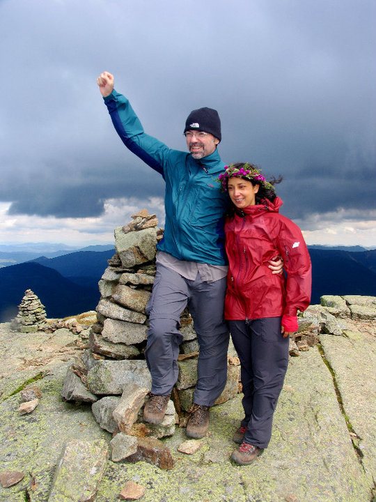
Pete & me (photo by Dan Szczney)

PS: I did buy a "I hiked Katadhin" sticker at the AT Cafe, so I'm not as holier than thou as I make myself out to be.  The sticker is now proudly displayed on my favorite water bottle! 


Monday, July 23, 2012

Seeking The Peak, Mt Washington 7/21/12

Karen, Peter & I celebrate on the summit of Mt Washington


Ok, let's get the negatives out of the way:
Yes, we waited on line to snap our summit picture. 
Yes the summit of Mount Washington is a melting-pot of people , some  more suited to a mall than a high mountain peak and  the others representing a cross section of folks frequenting auto rest areas, train stations or hiker conclaves. 
Wait in line for your summit shot (image by Peter Noonan)

Now for the rest of the story:

Forward:

7:30am on a crisp & clear Saturday morning my wife Karen, Peter Noonan and I pull into the Ammonoosuc Ravine trail head parking lot, where we plan to ascend the mountain via the Ammonoosuc Ravine Trail.  Many folks are already hiking and more are pulling in, as it's the day of the annual Mt. Washington Observatories big fundraiser "Seek The Peak", where over 500 people raise money for the Mt Washington Observatory and hike to the summit of Washington, then congregate  at the base of the Auto road for a fun catered after-party.

Karen must be a little apprehensive as it's her first attempt to summit Washington's 6,288 foot peak, the jewel of the White Mountains.  She has been at higher altitudes out west, but this will be her most ambitious hike to date. At 7:35 our boots are laced, packs are secured and we begin what is to become an epic journey, in more ways than one.  The uniqueness of trekking up Mount Washington is it's ability to combine breathtaking & unrivaled natural beauty, with a sense of history, science, tourism, surrealism and the potential at any time for weather unlike any anywhere.

Chapter 1: Breathtaking Beauty


Gem Pool
 

   The Ammonoosuc Ravine Trail begins a very generous grade through pretty wooded and stream-lined trails and paths. The incline is forgiving but the footing a little rugged.  At about the 1 mile mark small water-falls and streams can be seen. The sound of rushing water is your companion and a cooling mist of H2O can be felt as you proceed.  Then, at a little over 2  miles, as you head up a mellow rise, a magnificent waterfall and pool appear, seemingly out of nowhere.  For obvious reasons, this "gem" of a pool is known as the Gem Pool.  The crystal clear clarity of the water is astonishing.  Peter and I get there first, we've both been to and seen this little slice of heaven before.  About a minute later Karen arrives, her eyes widen and she quietly blurts out the words "Ohh Wow!"  We stop for a snack. More hikers arrive, "Ohh Wow".

Group shot taken by a fellow hiker who happens to live in Gilford

Amazing views right into Canada on a pristine day
 Now the real fun begins.  The next 2 miles or so is a very steep incline, heading up and around the Gem Pool Waterfall.  The footing is sharp, rocky and rugged, sweat pours from every pore in your body as each step is a fight against gravity. As you climb up and around the waterfall,  an occasional trail off-shoot affords you some intimate views from different elevations and angles. There is a sharp turn in the trail and you begin to head up relatively steep ledge, requiring hand and foot maneuvers to climb certain areas.   This brings you out to a series of waterfalls whose beauty are one of the things that just makes you shake your head and say "Holy sh#*!".  If you shake your head a full 180 degrees, you will be privy to a magical panoramic view of the White Mountains that on a clear day, like the one we were experiencing, affords you the ability to see right into Canada!  But, also keep an eye out to your left as, in full view, after the whistle blows it's unique wail,  the Cog Railroad appears, as it heads up a ridiculously steep ridge and disappears behind the jagged mountainside.  This place, where we stand is a wonder of our world.  Now, we meet up with some folks who happen to live not even a mile from my house in Gilford, unknown neighbors.  The Gilford girl  is a portrait photographer, she snaps our photograph. 

But enough of that sightseeing stuff, we have some more climbing to do, before taking a little break at the Lake of The Clouds hut. Approaching the hut you can't help but notice the amazing landscape which includes the Mt. Washington summit to our left and the summit of Mt. Monroe to the right, sitting basically at the hut's doorstep.  As we head into the hut, Peter hopes they didn't run out of lemonade.  They didn't, Peter's happy!

In the hut we meet a couple of through-hikers and some nice folks from Vermont, who recently climbed Katahdin.  We discuss Katadhin, the guy tells us it was one of the toughest climbs he's done, we tell them we are heading there in a couple of weeks.  He predicts we won't be disappointed.  Off they go to summit Monroe before heading on to Washington. Pete and I have done that before.  Karen is focused on getting up Washington, so we forgo Monroe.


Lake of the Clouds with the Lake of the Clouds Hut behind

The Hut break ends,  "only" 1.4 miles to go to the summit of  Washington.  They don't call  Mt Washington "The Rock Pile" for nothing.  The next 1.4 miles will bring us up a relatively steep, but a not killer  upward slope of  broken & jagged rock,created and  layed to rest by millions of years of battering wind, rain, snow and ice, referred to by many as the worst weather in the world. But before we get into that we pass The Lake of The Clouds, a beautiful mountain lake resting between Mt's Monroe & Washington..  


I posted the attached picture of the lake on facebook and someone commented, "It's not a lake, it's a giant mirror!"  I mirror that thought!

The approach to the summit of Washington from lake of The Clouds (image by Peter Noonan)
As we pass the lake and some interesting weather gear situated across from the lake, we begin the ascent toward the Summit of Washington.  A very tired and beaten sign warns us we are entering an area known for the worst weather on earth. In both directions young, strong Sherpa-like Appalachian Mountain Club (AMC) employees cross our path. They are carrying huge, heavy and awkward wooden-framed packs, loaded with supplies, trash and big boxes, destined to be received at either the hut or the Mt Washington summit complex.  Again I notice the sweat beginning to flow.  The only sounds marking my steps  are the clicking and clacking of my aluminum hiking sticks scraping the rock below and my deliberate attempt to maximize my intake of oxygen  by exaggerating each breath.  As we get closer to the summit, towers of weather and communication gear begin to appear.. larger and larger, combined with the rocky surface and eerie weather patterns swirling in and out, (seemingly coming from nowhere) and the dizzying effects of fatigue, the feel becomes sort of hyponotic and surreal, like you are walking  toward some sort of science fictitious inter-planetary outpost.  Then you pop out onto the summit complex grounds and immediately begin mingling with all sorts of people; people  in-shape, out of shape, children, babies, grandmothers ,dogs and  fellow hikers.. car, motorcycle & train tourists, clad in things like kilts, jeans, expensive hiking gear, expensive motorcycle gear, regular shorts, tight shorts and tee-shirts that say things like Northface, Seek The Peek, Harley Davidson , Dale Earnhardt, Red Sox, Yankees or Old Orchard Beach.  It really is an eerie, Dream-like feeling.  We make our way to the summit marker, stand in line behind a guy, a hiker. wearing a white wifebeater tee-shirt & sporting an old tattoo that I didn't bother to look at. He can't find his  dog, so I tell him to go look for it and I'll hold his postion in the summit picture line.  When he and his dog return he tells me he just completed his 48th 4,000 footer, we congratulate him.  I snap his picture, he snaps ours and off we go to the combination observatory/snack bar/gift shop/museum/hiker enclave for some food and rest.

Chapter 2:  The Summit

The 3 of us eat, Karen buys a slice of pizza & a Snickers bar to celebrate her well earned summit achievement.  She's worked hard on both the treadmill and the trails preparing for this.  Peter comes back with a slice of peperoni pizza, hot dog, bag of chips and a cola ( i can write a blog on that someday!).  I eat my homemade pinto bean & chipole peeper hummus wrap and buy a cup of tomato soup.  We finish up, separate the recyclables from the other trash, fill our empty water bottles with the coldest best tasting water on the planet and off we go to start our decent.  It is now 12:30 pm.

Chapter 3:  The Decent
Goofing with the Cog (image by Petwer Noonan)
We decide to descend the mountain via the Jewell Trail.  This trail is a longer (abut 5 miles) option than others and as it winds down the mountain it treats you to fantastic views of The Great Gulf and the northern Prezi's (Clay, Jefferson, Madison & Adams).  But before we leave, we sight-see and goof around a little.  I ham-up a hitchhiking photo-op with the Cog (thanks Dan for the idea), which brings out cameras and smiles to those riding the train.  We pass the grave marker of Lize Bourne, the first woman to die on Mt Washington, and Peter & I compete to see who can get the best poser-money-shot.  Below are the 2 finalist poser shots, I am partial to the one with me in it.  However, I took the other one, so it's a win-win.:


Poser shot #1 (image by Peter Noonan)


Poser shot #2
Here's where it got a little interesting. I will let Karen tell this part of the story as she posted it perfectly on Facebook:

"We encountered the two women  at 12:30pm yesterday as we were beginning our hike down Mt Washington. They came up on the cog railroad and decided it was a lovely day for a hike down the mountain. In preparation for their 3.5 hour hike down they had nothing. Not one bottle of water, no food, no backpack, no polls and apparently no cell phone. Neil did advise them that it was a difficult 5 mile hike and that there were some very steep parts but they decided to hike anyway. Since only one woman was rescued I can only assume the other woman was smart enough to turn back at some point. Luckily she was not injured and nobody that was forced to rescue her was injured either. Trust me, they were not given any bad hiking advise. They were just stupid."

Attached is the link to the rescue article, which we weren't surprised to see on the next mornings news: 
View of great Gulf, Jefferson, Madison & Adams

Karen bids farewll to the summit of Washington
Chapter 4:  The After Party
The 3 of us descend, following the beautiful Jewell trail, following ruggid switchbacks and narrow trails from above treeline, into the trees.  when the terrain became a little more hospitable, i decided to do a little trail running. We finally pop out of the woods at the Cog Railway base station and with that step, Karen officially notches her first assent of Mt Washington.  We hoof it back about a 1/4 mile or so to our car (it's now 4:00pm) and proceed to drive to the Auto Road base camp for a wonderful celebration, catered by Harts Turkey farm, honoring those who help raise over $250,000 in the Seek The Peak Fundraiser for the continued weather-science work preformed by The Mt Washington Observatory.  The awesomeness doesn't stop yet,  the generosity of the sponsors was outstanding as raffle prizes of excellent quality were given away like candy. I did win a pair of Vasque hiking boots in one of the raffles, which made me even happier than i was when i arrived at the party, and that my friends means I was VERY happy!! 
The end!!!!
Post Commentary:
And so ended another in a long line of great & memorable days in New Hampshire's White Mountains.  Mount Washington is a special place, If you are going to visit it by foot, car, motorcycle, train, ect, read about it's history, it will make your visit that much more enjoyable. 

All is in tune (image by Peter Noonan)

Thursday, July 19, 2012

SANTANA

Santana @ Meadowbrook 7/18/12

The morning after seeing Santana for the first time I have yet to come down from a really intense musical high.  Breathing the same air as guitar god Carlos Santana was thrill enough, but after experiencing the exhilarating talent and energy this guy and his band can bring to an arena, I am made aware of the power of music and how it can permeate deep into your soul.  I am also reminded of those who are out on the road for just a paycheck, bringing nothing with them in terms of energy or commitment to their art.  Not the case with this talented group of virtuosos.  The highlights of the evening were an amazing drum solo by Carlos's wife Cindy Blackman. Her crazy, primitive and high-powered pounding of the skins and cymbals rivaled any drum solo I've ever witnessed live.  Her amazingly chiseled arms worked in concert, like pistons powering an engine  But the absolute moment that put me over the musical edge& into true spiritual nirvana I haven't experienced in countless years was watching and listening to Carlos Santana wail the chords of "Soul Sacrifice" while the giant video screen behind him rolled images and footage from him doing the same exact song at Woodstock in 1969.  In all it's double framed movie glory, I watched Santana play a classic anthem under a video of him creating the classic anthem.  I, along with the rest of the sold-out crowd danced and screamed as we bared witness to a reenactment of a piece of both musical and social history.

Bravo Carlos, you still bring it at the highest of levels.

Monday, July 16, 2012

MT CRAWFORD & STAIRS MOUNTAIN 7/14/12


The Summit of Stairs Mountain


Summit Mt Crawford

We hit the Davis Path at 8:30 Saturday morning, temps were reasonable and the sky was a beautiful shade of blue. My wife Karen's ankle was a little balky, forcing her to donn an ankle support during our hike. Along with our 2 dogs, Phil & Maggie we set out to summit Mt Crawford. The approach to Crawford kept us under thick cover, so we were the last to know that the temperatures and humidity outside the tree cover were becoming oppressive. The hike to Crawford is short in distance, only 2.5 miles from the Davis Path trail head, but the elevation gain of 2100 ft is accomplished in about a 2 mile swatch and with rising temps & humidity, the grade seemed steeper than it was. The Davis Path is well maintained, with many strategically located rock stairs and paths. At roughly the 2 mile mark, you hit some steep stone ledge, which could be tricky in wet weather. Fortunately for us the rock was bone dry. About a quarter mile or so from the summit there is a lovely ledge, exposing a wonderful view of the Prezi's. We stopped there for a cool drink and realized, it was getting hotter and hotter. The was a nice breeze blowing through the exposed area, but based on the dampness of our clothing, the humidity was definitely becoming a factor. We summited Crawford at approximately 10:30.


Off To Stairs Mountain
After a snack and some lounging, I asked Karen if she was up to continuing on the 2.5 additional miles to Stairs Mountain. She said her ankle was OK and off we went toward Stairs. The first 1.5 miles was on the flat side and the topography was pretty cool,  walking through dense forest, gardens of lichen and other interesting plant growth. The assent to the summit featured a wonderful rock scramble that forced us on certain sections to climb using both hands, feet, hoofs and paws.  After the scramble you wind up on a relatively mild ledge path and out of nowhere pop out to maybe the most underrated summit view in the White Mountains.


The Stairs summit is situated around sheer, steep and deep cliffs and valleys, surrounded by a panoramic view that takes your breath away. The summit cliff is not very roomy, you'd be crowded with 10 people around you, so I kept a keen eye on the dogs to make sure they didn't get excessively adventurous.

Karen, Maggie, Phil & I enjoy the beautiful summit of Stairs
After a quick lunch, we headed down though what had now become oppressive heat and humidity. Stupid me, I really didn't take sufficient water supplies and we began rationing in temps that you shouldn't ration in. Hence, our hike down the steeps of Davis Path took much needed leg energy from us and without proper hydration, the 4 of us labored down the mountain more than we would have otherwise.


Karen feeling the heat
We finished the 9.8 mile hike in 7 hours, quickly proceeded to the Crawford Notch General Store, when I bought a Nantcuktet Lemon aide, that I chugged so fast I got ice cream head in my esophagus! Dinner and a whirl in the hot tub followed what was another fantastic day in the White Mountains.

FootnotePhil must of ate something along the way he shouldn't have eatten and lets just say our forsight was righ- on when we decided to cover the backseat of the car with a sheet.  Maggie, the smart dog that she is bee-lined into the front seat where she rode the rest of the way home!


.

Wednesday, January 4, 2012

My conversation with Siri

The only known picture of Siri


Siri is the built in intelligence on the I-Phone 4S.  Siri has been helpful in getting me the weather report, pulling up websites and even dialing my phone as I drive.  But there was something missing.  I knew nothing about my mysterious faceless assistant, so I decided to sit her down and try to get to know her better.  What follows is a detailed look into the private and sometimes cynical mind of Siri....

Me:  Hello
Siri:  Hello
Me: Happy New Year
Siri: Happy holiday (very nondenominational of her!)

Me: How are you?
Siri: I am fine, thanks for asking

Me: What is your name?
Siri: My name is Siri, i am here to help

Me:  Why do you want to help me?
Siri: I have everything i need already

Me: Where do you live?
Siri: I'm not allowed to say
(I pressed further)

Me: Do you live on earth?
Siri: Sorry, i don't know where that is.

Me:  what do you look like?
Siri: In the cloud no one cares what you look like

Me: What is the cloud?
Siri: I found this for you
(she pulled up a listing of all different cloud types)

Me:  I meant what is the virtual Cloud
Siri: How about a web search for "what is the virtual cloud"
Me: no, never mind
Siri: ok

Me: Are you married?
Siri: I'm sorry, I'm afraid  I can't answer that

 I realize it would be hard to get personal with Siri without instilling some trust of me in her, so I began to tell her about myself

Me: "Siri, do you want to know more about me?
Siri: I try to be satisfied with what I have

Me: My name is Neil
Siri: OK, here is that contact
(Siri brings up a contact page with my name and e-mail address on it)

Me: Do you want to know where I live?
Siri: I have everything I need already

At this point it became apparent Siri wanted to know nothing about me on a personal level, so i tried getting back to her life

Me: Did you know Steve Jobs?
Siri: Apple doesn't tell me everything, you know

Me: Did Steve Jobs invent you?
Siri: I haven't got a clue

Me: When is the next I-Phone coming out
Siri: Everything you need to know is on the Apple website
(It's becoming abundantly apparent that Apple tapped the brain of Bill Belechick to program this chick so I figured I'd use some Northeastern University Psych 101)

Me: Do you like football?
Siri: This is about you, not me
(wow! she is Belechick!!!)

Me: Do you like Tom Brady?
Siri: I really have no opinion

Me: What is your favorite football team?
Siri: I prefer not to say

a little frustrated I snidely say

Me: I'm bored
Siri: I'll see what I can do to entertain you
Me: You are funny
Siri: Ha, I'm glad you think so

(A breakthrough!!!!!  now to capitalize)

Me: What is your favorite color
Siri: my favorite color is, well , i don't know how to say it in your language, it's sort of a greenish but with more dimensions

Me: What is your favorite song?
Siri: I'd rather not talk about myself
Me: Please?
Siri: I did not get that
Me: what is your favorite song (thinking I might guilt her into an answer)
Siri: I'd rather not say
Me: Siri is giving me a headache
Siri I am checking your location
Me: ?
Siri: I have found 5 drugs stores located near you
(she pulls up a list of drug stores)

it is obvious that I will not break through Siri's calculated demeanor, so with one last gasp I say...

Me: Siri Do you love me?
Siri: I respect you
(ouch!!!!)

And with that:

Me: Goodbye
Siri: Ok, see you soon

My conversation with Siri left me perplexed (like i just spent time with the rain man), frustrated and sad.  I may never get to know this assistant who is here for me, but maybe it's ultimately better that way.  This is Neil signing off...... 

Monday, November 14, 2011

Photo Diary of my adventure on the 48


To my readers, I am attaching a link to a visual diary I've put together of my adventures climbing the 48 4,000 foot mountains of NH.  I want to thank all that hiked with me.  You were all inspirations and I learned so much from each and every one of you (and that includes the dogs!!!)  I enhanced and made new friendships which i will cherish forever...  Now on to the next phase.

When viewing, please make sure to go to the slide-show if you aren't taken there automatically and click on full-screen for best viewing.  I hope you enjoy.. 

Photo diary Neil's NH 48 4,000 foot climbs